Loading cart contents...
Murujuga by Sally McEnallay
Murujuga: Between rocks and hard places
I acknowledge the Ngarluma people as the traditional custodians of Murujuga and pay respect to Elders past, present and emerging. The following account is based on my own experience of a visit to Murujuga and I appreciate the access I was granted to Country and its stories while I was there.
Something feels off as soon as you reach the causeway that joins the city of Karratha to the Burrup Peninsula. Although the winter temperature here in Australia’s far Northwest is nudging thirty-two degrees, we appear to be driving past a series of frozen ponds. The water glows pearlescent in the early light and dotted across the surface are several small metal sculptures, one of them a figure skater preparing to glide across the ice. But these ponds, known locally as Anchovy Flats, are shallow salt pans owned by the Dampier Salt Company. Their eerie glow is just the reflection of the cloudless blue sky in the pinkish calcium-carbonate-saturated water.
Beyond the causeway the landscape turns rugged. Precarious heaps of rusty coloured boulders loom either side of us. ‘Was this all for the mines?’ asks J. And it’s a good question. We are the only car on this road. All the other vehicles are dust-crusted road trains – elongated lorries ferrying iron ore, gas tanks and machinery in and out of the chain-link gates that separate the mining operations from the public road. But the boulders are too big to be construction rubble. It looks more as if a giant has split these massive rocks with a pickaxe while digging for treasure. But this weird landscape has been shaped by geological, not mythological, forces. Water droplets inside this porous granite freezing and melting over millennia, have fractured sheer cliffs into this vast boulder field exposing thousands of hard smooth tablets which hold some of the world’s oldest rock art.
Murujuga is an unlikely place for a gallery. The name means ‘hip bone sticking out’ in the local Aboriginal language and this thin, rocky peninsula, tacked to the side of the Western Australian mainland by the causeway we have just crossed, is a landmass of contradictions. Murujuga lies in the Pilbara, one of Australia’s most remote regions and the source of the country’s richest exports – iron ore, salt, liquified natural gas, gold, lithium, zinc and cobalt. The extraction and processing of these materials has generated billions of dollars for the Western Australian government and its mining partners since the 1960s. Murujuga is also part of the state’s 100th National Park and the first to be jointly managed by the WA government and the traditional Aboriginal owners. In July 2025 it was granted World Heritage status by UNESCO as the site of the largest and oldest concentration of petroglyphs (rock art) ever discovered.[1] We rattle down a dirt track into Nganjarli car park, where one of the park rangers is waiting to show us around.
At 8am the sun is already hot, so we wait in the shade of a mulga tree for the last few stragglers to join the tour. At our feet a troop of bush ants march across the path heading for a crack in the low wall on the other side.
‘Watch out,’ grins our guide. ‘Those buggers gonna bite you through your socks.’ We step hastily backwards.
Our guide, R, is a Yawuru-Ngarluma man born in Broome, 800 kilometres north of here and brought up in Perth 1500 kilometres south. He has cousins here on the Burrup who already work for MAC (Murujuga Aboriginal Corporation) the Aboriginal collective that manage the park, who suggested he apply to work here. He is perhaps twenty, with blonde tipped curly hair, a gold earring and perfectly pressed shorts. He seems nervous as he leads our small group of bush-hatted tourists up the board walk towards the first information point.
Just as we arrive, a kangaroo pops up between two rocks halfway up the hill, stares at us for a few seconds and then bounds sure-footedly down the slope into the safety of the bush. R has brought a laser pointer but at first the angle of the sun makes it hard to see anything. After a few minutes of squinting I make out the outline of a kangaroo etched onto a large flat rock. It is as if the live animal had sprung straight out of the hillside leaving just his shadow behind. Now that my eyes have adjusted, images appear everywhere. I had expected relief carvings, but these are flat outlines and shaded areas, pecked and stippled onto the rich red surface layer to expose the pale rock underneath. One of the group asks how old the images are. I sense that R finds the question bemusing. He shrugs. ‘Oh, thirty, forty thousand years, something like that. They know that is one of the youngest ones.’ He points to the outline of a whale tale. ‘That’s only ten thousand years or so.’
We are used to digging up the past. Our history hides underneath, requiring forensic and patient excavation sometimes with tweezers and small brushes. But here the past is on the surface – viscerally present. R shows us another kangaroo image. This one appears flattened as if run over by one of those monster road trains that passed us on the way here. He tells us this diagram illustrates the correct way to butcher a kangaroo. A few yards further on we spot an emu lying on its back. This picture corresponds to Gugurmin, an emu shaped streak of gas clouds that cross the Milky Way and are visible in the Southern Sky. At certain times of year, the sky emu stands upright indicating the right time to hunt for emu eggs. But if she is on her back like the rock image she is laying and must not be disturbed. I struggle to imagine R hunting emu eggs but he shares this information as casually as if he were relaying the result of Saturday’s local rugby league match.
There are thought to be over 1,000,000 petroglyphs here but only 45,000 have so far been catalogued and many were destroyed or moved before the site was granted national heritage protection in 2007. There are many signs here that R cannot read or does not have access to, because, for example, they denote sites related to ‘women’s business.’ He hopes that drone technology might make it easier for the ‘old people’ who can read the rocks but can no longer physically access the boulder fields, to share their knowledge. Another obstacle is that the artists who created these images were ancestors of the Yaburara people whose last direct descendants were wiped out in a notorious colonial genocide known as the Flying Foam Massacre.
Drive fifteen minutes north of the rock art trail and you’ll reach a narrow sea channel that separates the islands of the Dampier Archipelago from the main peninsula. This is Flying Foam Passage. Along the ridge of the cliffs ninety-three standing stones bristle against the sky like spines on an echidna. These stones are a memorial to the ninety-three Yaburara people killed in a series of violent skirmishes in February 1868.
Although there were thought to be about five hundred Yaburara living on what was then Burrup Island at the time of first contact in the mid eighteenth century, drought and smallpox decimated the community so that a hundred years later less than half that number survived. The pearl shell industry was booming and Aboriginal people were often coerced into working on the boats as slave labour. Relations between the Yaburara and the small local group of white settlers were hostile and the local police were notoriously corrupt.[2]
Official reports have it that R.J. Sholl, the local government representative, despatched two groups of armed pastoralists and police to the Burrup to apprehend three Aboriginal men accused of killing three white men, and a ‘native’ police assistant and that up to thirty ‘natives’ died in the process. Aboriginal testimonies state that only one white man, a policeman, died – speared to death by the husband of a young Aboriginal girl he had abducted and raped.
Whatever the cause, the result was a violent rampage that lasted several days in which the Yaburara, including women and children were driven north onto the cliffs of Flying Foam Passage, where they were either shot or forced to leap to their deaths on the jagged rocks below. With the traditional custodians gone, their neighbours, the Ngarluma, Yindjibarndi, Mardudhunera and Woon-goo-tt-oo peoples became the uneasy caretakers of Yaburara country.
Nearly two centuries of care have given this group, known collectively as the Ngarda-Ngarli an undisputed connection to the Burrup. However, the rupture between clan and country inflicted by the Flying Foam Massacre meant that no Native Title Claim was granted here until 2001. The Ngarluma people were finally recognised as the official custodians and a group of elders signed an agreement with the Western Australian government leasing back part of the peninsula for industrial development in exchange for community investment, and a guaranteed involvement in future development plans. R worries that they were tricked.
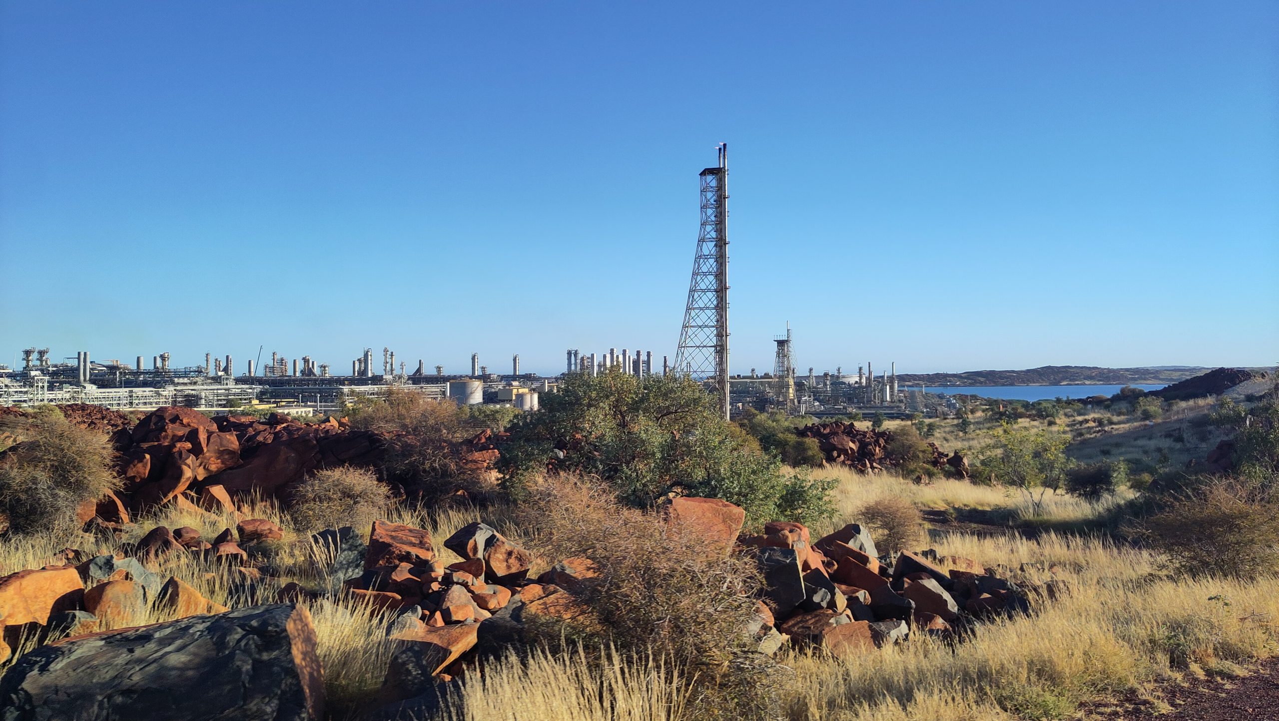
Just beyond the car park is a sprawling network of tanks and metal pipework like something from a science fiction film set. This is the Karratha Gas Plant and it hugs the shoreline for miles in both directions. The plant is the processing centre for the natural gas that is sucked down 156 kilometres of undersea pipe from the North West Shelf Gas Field, one of the largest LNG (liquified natural gas) projects in the world. The North West Shelf project supplied 14% of Australia’s domestic gas in 2024 and has despatched more than 6000 container ships of LNG to markets in China, India and Japan since 1989. Woodside Energy, the major partner in the project, has been in the Burrup since 1963 and employs over 2000 people many of them local and some of them Aboriginal. The project has invested over $300 million AUD in the local community and their literature states that: ‘We take our responsibility to manage cultural heritage seriously, guided by Traditional Owners, heritage experts and credible science.’[3]
Liquified Natural Gas Is championed as an interim fuel in the global transition to clean energy since it emits less that 50% of the carbon released by coal when burned. This makes it a popular choice for coal fired economies like China and India as they strain to meet their emission reduction targets. But the processing and transport of this fuel over thousands of kilometres also generates emissions and scientists worry that methane, a much more potent greenhouse gas than carbon, is being produced during both stages and is not currently measured. The damage inflicted on both land and sea-based eco-systems by the construction, maintenance and eventual decommissioning of a project the size of the North West Shelf Project must also be taken into account.
R expresses the hope that the recent UNESCO listing will protect the rock art from these threats, but I don’t share his optimism. Recently Murray Watt, National Minister for the Environment and Water, approved the extension of the North West Shelf operation until 2070. Australia like many other nations, including the UK, has committed to reaching net zero emissions by 2050 under the legally binding terms of the Paris Agreement. In reaching his decision, Minister Watt referenced the extensive research produced by the Murujuga Rock Monitoring Program jointly commissioned by Woodside, MAC and the Western Australian government and authored by scientists from Curtin University. Their latest report reveals evidence of damage to the rock art by current emissions from the nearby plant which will worsen as operation continues. Watt concluded that this was a price worth paying for the economic benefits that would accrue from another forty five years of gas production from the North West Shelf project.[4] Professor Adrian Baggedly, chief statistician on the air monitoring team, resigned his role in protest, claiming that the Western Australian government had manipulated scientific data in their presentation to the Canberra committee. This debate rumbles on but although UNESCO listing will attract both attention and visitors to this remarkable place it looks unlikely to provide protection from either the local or global impacts of climate change.
After the rock art tour we visit the nearby Woodside Visitor Centre where a rusted iron sculpture commemorates an accident that occurred during the building of the gas plant. Through its triangular frame the distant coastline of Flying Foam Passage shimmers in the heat. I struggle to separate the layers here. The North West Shelf project sucks from the seabed a gas that has built up over millennia and delivers it to Australian homes to heat tonight’s supper. Invisible emissions accumulating in the air threaten the future of rock art created by people thousands of years in the past. And we are all complicit in this damage. The Ngarda-Ngarli talk about their creation stories not in terms of ‘Dreamtime’ as other groups do, but as a time ‘when the land was soft.’ It feels right to recognise that this is still the case – our planet remains vulnerable, malleable and porous. Now we need to choose what kind of marks we want to leave here.
References
[1] ‘Murujuga National Park: Visitor Guide,’ leaflet, Parks and Wildlife Service, Western Australia
[2] ‘The Flying Foam Massacre, by Tom Gara, https://www.parliament.wa.gov.au/publications/tabledpapers.nsf/displaypaper/4014314cf920c2f875dc796a482585ec008206a9/$file/tp-4314.pdf
[3]‘North West Shelf Project Extension’, information sheet, Woodside Energy
[4] ‘Federal government agreed to weaken proposed protections for rock art from Woodside’s North West Shelf project’ Adam Morton and Lisa Cox, Guardian (Australia), 29th September 2025 https://www.theguardian.com/australia-news/2025/sep/30/woodside-north-west-shelf-gas-indigenous-rock-art-murujuga-federal-government-environment-minister-murray-watt-western-australia
***
Sally McEnallay is a writer of narrative non-fiction and memoir from Scotland but currently lives in London. She is interested in exploring the relationship between human and non-human nature in the hope that it has a future. When not writing she is often to be found walking a spaniel or reading three books at once. Follow her on Instagram here.
Photograph by the author.